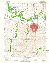
1965 Map of Concordia
USGS Topo · Published 1966About this map
Concordia serves as a dense hub of transit and civic activity in this mid-1960s survey, where three major railroads—the Atchison Topeka and Santa Fe, the Chicago Burlington and Quincy, and the Missouri Pacific—converge south of the Republican River. The city is meticulously detailed with landmarks like the Courthouse, City Hall, and the Nazareth Convent, alongside numerous neighborhood schools such as Washington Sch and McKinley Sch.
Find a feature on this map
47 named features on this map. Tap any name to fly to it.
Don’t see what you’re looking for? This feature index may not catch every label — zoom into the map to look around manually.
Map Details
Editions of this 1965 Concordia Map
2 editions found
Other maps of this area

1892 · Concordia
USGS Topo · 1:125,000

1892 · Minneapolis
USGS Topo · 1:125,000

1953 · Glasco NE
USGS Topo · 1:24,000

1955 · Manhattan
USGS Topo · 1:250,000

1956 · Manhattan
USGS Topo · 1:250,000

1957 · Manhattan
USGS Topo · 1:250,000

1965 · Aurora
USGS Topo · 1:24,000
1965 · Aurora NW
USGS Topo · 1:24,000

1965 · Wayne
USGS Topo · 1:24,000

1965 · Concordia NW
USGS Topo · 1:24,000