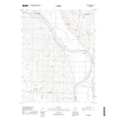
2017 Map of Jamestown
USGS Topo · Published 2017About this map
The Missouri River carves a winding path through the borderlands of Boone and Moniteau Counties, defining a landscape of dramatic river bends and fertile bottoms. Along these sweeping curves lie named reaches such as McBaine Bend, Lupus Bend, and Plow Boy Bend, each marking the shifting history of the waterway. Small settlements like Lupus, Providence, and Easley anchor the riverbanks, while Jamestown sits further inland to the southwest, connected by a network of rural routes including Possum Trot Rd and State Hwy Y.
Find a feature on this map
71 named features on this map. Tap any name to fly to it.
Don’t see what you’re looking for? This feature index may not catch every label — zoom into the map to look around manually.
Map Details
Editions of this 2017 Jamestown Map
This is the sole edition of this map. No revisions or reprints were ever made.
Other maps of this area

1886 · Jefferson City
USGS Topo · 1:125,000

1888 · Boonville
USGS Topo · 1:125,000

1894 · Jefferson City
USGS Topo · 1:125,000

1935 · Columbia
USGS Topo · 1:24,000

1940 · Columbia
USGS Topo · 1:24,000

1947 · Jefferson City
USGS Topo · 1:250,000

1948 · Centertown
USGS Topo · 1:62,500
1948 · Columbia
USGS Topo · 1:24,000

1948 · Columbia
USGS Topo · 1:62,500
1949 · Centertown
USGS Topo · 1:62,500