
1948 Map of Columbia
USGS Topo · Published 1960About this map
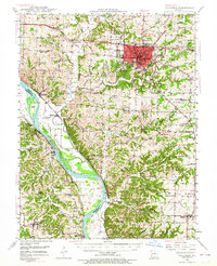
The University of Missouri and the surrounding academic core of Columbia dominate the northeastern portion of this mid-century landscape. This area, anchored by Stephens College and Christian College, shows a sophisticated educational hub supported by the Wabash railroad and the Municipal Airport. Beyond the urban center, the terrain transitions into the complex drainage systems of Hinkson Creek and Perche Creek as they flow toward the Missouri River.
Find a feature on this map
87 named features on this map. Tap any name to fly to it.
Don’t see what you’re looking for? This feature index may not catch every label — zoom into the map to look around manually.
Map Details
Editions of this 1948 Columbia Map
2 editions found
Other maps of this area

1886 · Jefferson City
USGS Topo · 1:125,000

1888 · Boonville
USGS Topo · 1:125,000

1890 · Moberly
USGS Topo · 1:125,000

1890 · Glasgow
USGS Topo · 1:125,000

1894 · Jefferson City
USGS Topo · 1:125,000

1917 · Sturgeon
USGS Topo · 1:62,500

1935 · Columbia
USGS Topo · 1:24,000

1939 · Jefferson City
USGS Topo · 1:62,500

1940 · Columbia
USGS Topo · 1:24,000

1942 · Jefferson City
USGS Topo · 1:62,500