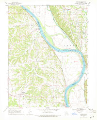
1969 Map of Jamestown
USGS Topo · Published 1971About this map
Jamestown anchors the southwest corner of this landscape, situated on the high ground overlooking a network of creeks that feed into the Missouri River. The river corridor dominates the eastern half of the map, carving a wide valley that serves as a vital transportation artery for the Missouri Pacific and Missouri Kansas Texas railroads. Small riverfront settlements like Lupus, Sandy Hook, and Easley highlight the historical reliance on these rail lines and the river for commerce and travel.
Find a feature on this map
27 named features on this map. Tap any name to fly to it.
Don’t see what you’re looking for? This feature index may not catch every label — zoom into the map to look around manually.
Map Details
Editions of this 1969 Jamestown Map
This is the sole edition of this map. No revisions or reprints were ever made.
Other maps of this area

1886 · Jefferson City
USGS Topo · 1:125,000

1888 · Boonville
USGS Topo · 1:125,000

1894 · Jefferson City
USGS Topo · 1:125,000

1935 · Columbia
USGS Topo · 1:24,000

1940 · Columbia
USGS Topo · 1:24,000

1947 · Jefferson City
USGS Topo · 1:250,000

1948 · Centertown
USGS Topo · 1:62,500
1948 · Columbia
USGS Topo · 1:24,000

1948 · Columbia
USGS Topo · 1:62,500
1949 · Centertown
USGS Topo · 1:62,500