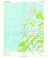
1943 Map of Jamesville
USGS Topo · Published 1962About this map
Occohannock Creek serves as the dividing line between Accomack and Northampton Counties, carving deep into the Virginia Eastern Shore landscape. This coastal survey reflects a mid-century economy built on the water, marked by numerous small landings such as Davis Wharf, Stewarts Wharf, and Concord Wharf. Further inland, the settlements of Jamesville and Wardtown are connected by a network of rural roads that pass country landmarks like Bethel Church and Mt Zion Church.
Find a feature on this map
42 named features on this map. Tap any name to fly to it.
Don’t see what you’re looking for? This feature index may not catch every label — zoom into the map to look around manually.
Map Details
Editions of this 1943 Jamesville Map
2 editions found
Other maps of this area

1942 · Nandua Creek
USGS Topo · 1:24,000

1942 · Nassawadox
USGS Topo · 1:24,000

1943 · Nassawadox
USGS Topo · 1:31,680

1943 · Jamesville
USGS Topo · 1:31,680

1943 · Pungoteague
USGS Topo · 1:31,680

1943 · Franktown
USGS Topo · 1:31,680

1943 · Exmore
USGS Topo · 1:24,000

1943 · Richmond
USGS Topo · 1:250,000

1944 · Exmore
USGS Topo · 1:31,680

1946 · Eastville
USGS Topo · 1:250,000