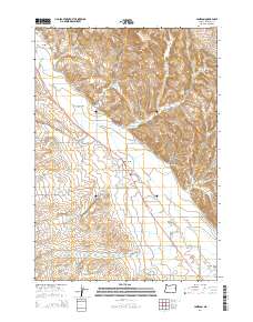
2014 Map of Jamieson
USGS Topo · Published 2014About this map
Jamieson and Brogan anchor this agricultural landscape in the high desert of eastern Oregon, where water management defines the local economy. The Willow Creek Valley is the central geographic feature, supported by a complex network of irrigation infrastructure including the Vale Oregon Main Canal, Brogan Ditch, and E State Ditch. These man-made watercourses redirect flows from Willow Cr and its many tributaries, such as Poison Cr and Turner Cr, to support the surrounding fields. Near the settlement of Jamieson, the Dell Cem provides a genealogical touchstone for families of the region. The terrain is marked by distinct drainage features like Stone Quarry Gulch and Mattock Gulch, while the John Day Hwy serves as the primary transport artery through this Malheur County corridor.
Find a feature on this map
49 named features on this map. Tap any name to fly to it.
Don’t see what you’re looking for? This feature index may not catch every label — zoom into the map to look around manually.
Map Details
Editions of this 2014 Jamieson Map
This is the sole edition of this map. No revisions or reprints were ever made.
Other maps of this area

1950 · Jamieson
USGS Topo · 1:62,500

1951 · Huntington
USGS Topo · 1:62,500

1955 · Baker
USGS Topo · 1:250,000

1959 · Baker
USGS Topo · 1:250,000

1964 · Bridgeport
USGS Topo · 1:62,500

1964 · Brogan
USGS Topo · 1:62,500

1980 · Brogan
USGS Topo · 1:100,000
1987 · Willowcreek
USGS Topo · 1:24,000
1988 · Birch Creek Meadow
USGS Topo · 1:24,000
1988 · Mc Carthy Ridge
USGS Topo · 1:24,000