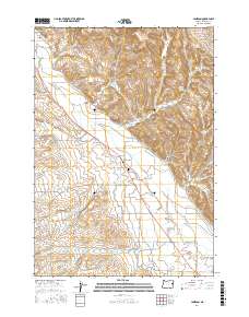
2017 Map of Jamieson
USGS Topo · Published 2017About this map
Jamieson and Brogan serve as the primary anchors for this rural landscape in Malheur County, where the desert terrain is shaped by an intricate network of water management. The Vale-Oregon-Main-Canal cuts across the southern portion of the map, part of a larger system that includes the Brogan Ditch and E Side Ditch, illustrating the area's dependence on irrigation for agricultural life. The Willow Creek Valley dominates the eastern half of the sheet, fed by numerous tributaries such as Lick Cr and Poison Cr. For those researching local family histories, the Dell Cem is a notable landmark located just east of Jamieson. The terrain is marked by deep drainage features like Stone Quarry Gulch and Mattock Gulch, while a grid of local roads like Maag Rd N and 12th Ave W connects the scattered homesteads and ranching tracts.
Find a feature on this map
47 named features on this map. Tap any name to fly to it.
Don’t see what you’re looking for? This feature index may not catch every label — zoom into the map to look around manually.
Map Details
Editions of this 2017 Jamieson Map
This is the sole edition of this map. No revisions or reprints were ever made.
Other maps of this area

1950 · Jamieson
USGS Topo · 1:62,500

1951 · Huntington
USGS Topo · 1:62,500

1955 · Baker
USGS Topo · 1:250,000

1959 · Baker
USGS Topo · 1:250,000

1964 · Bridgeport
USGS Topo · 1:62,500

1964 · Brogan
USGS Topo · 1:62,500

1980 · Brogan
USGS Topo · 1:100,000
1987 · Willowcreek
USGS Topo · 1:24,000
1988 · Birch Creek Meadow
USGS Topo · 1:24,000
1988 · Mc Carthy Ridge
USGS Topo · 1:24,000