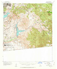
1955 Map of Jamul
USGS Topo · Published 1963About this map
The Brown Field Naval Auxiliary Air Station and the associated Brown Field Bombing Range dominate the southern landscape just north of the United States Mexico border. This mid-century survey captures a period of transition for San Diego County, where burgeoning communities like Spring Valley and Jamul sit alongside expansive agricultural holdings such as Otay Ranch and Ivanhoe Ranch. Water management is a defining feature of the region, illustrated by the presence of Sweetwater Reservoir, Upper Otay Reservoir, and Lower Otay Reservoir, which served the growing coastal population. Rugged peaks like Lyons Peak and Mother Miguel Mtn break up the valleys, while the Cleveland National Forest covers much of the eastern terrain. Traces of early social infrastructure remain visible through labels for Indian Church, The Oaks Sch, and the La Mesa Airport.
Find a feature on this map
69 named features on this map. Tap any name to fly to it.
Don’t see what you’re looking for? This feature index may not catch every label — zoom into the map to look around manually.
Map Details
Editions of this 1955 Jamul Map
3 editions found
Other maps of this area

1893 · El Cajon
USGS Topo · 1:62,500

1901 · Elcajon
USGS Topo · 1:62,500

1903 · Cuyamaca
USGS Topo · 1:125,000

1903 · La Jolla
USGS Topo · 1:62,500

1903 · Elcajon
USGS Topo · 1:62,500

1904 · San Diego
USGS Topo · 1:62,500

1904 · Southern California Sheet No. 2
USGS Topo · 1:250,000

1930 · La Jolla
USGS Topo · 1:62,500

1930 · San Diego
USGS Topo · 1:62,500

1939 · El Cajon
USGS Topo · 1:62,500