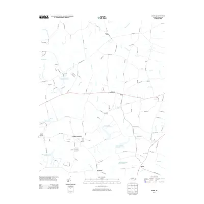
2013 Map of Jason
USGS Topo · Published 2013About this map
Cokers Crossroads and the surrounding coastal plain of eastern North Carolina define this landscape of small agricultural settlements and intricate drainage systems. The area is characterized by a series of watersheds, notably the Bear Creek W/S Lake Number Six and several other numbered reservoirs such as Lake Number Eleven, which manage the local water table. These basins feed into various prongs and runs, including the Long Shoal River and the meandering Nahunta Swamp to the north. Distinctive local names like Peanut Crossroads and Shines Crossroads highlight the region's intersectional rural hubs. The road network connects small communities like Parkstown and Jason, following the natural contours between creek branches and swampy lowlands such as The Slough.
Find a feature on this map
146 named features on this map. Tap any name to fly to it.
Don’t see what you’re looking for? This feature index may not catch every label — zoom into the map to look around manually.
Map Details
Editions of this 2013 Jason Map
This is the sole edition of this map. No revisions or reprints were ever made.
Other maps of this area

1904 · Falkland
USGS Topo · 1:62,500

1904 · Wilson
USGS Topo · 1:62,500

1914 · Kinston
USGS Topo · 1:48,000

1916 · Kinston
USGS Topo · 1:62,500

1953 · Rocky Mount
USGS Topo · 1:250,000

1954 · Rocky Mount
USGS Topo · 1:250,000

1957 · Goldsboro
USGS Topo · 1:62,500
1978 · Fremont
USGS Topo · 1:24,000
1978 · Stantonsburg
USGS Topo · 1:24,000
1981 · Walstonburg
USGS Topo · 1:24,000