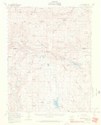
1967 Map of Jasper
USGS Topo · Published 1972About this map
The Rio Grande National Forest dominates this high-altitude landscape along the border of Rio Grande and Conejos counties. High mountain peaks like Bennett Peak and Greenie Mountain overlook a complex network of seasonal camps and administrative outposts, including the Fitton Guard Station and Alamosa Guard Station. The map illustrates a summer grazing economy through specifically named cattle operations such as Shawcroft Cow Camp and the Baxter and Martin Cow Camp. Water management is central to the area's geography, evidenced by the presence of La Jara Reservoir and the Alamosa Terrace Reservoir. Beyond agriculture, the terrain supports educational and recreational uses at the Phillips University Camp and the Lost Cabin Ranch, while several labeled mines and gravel pits indicate localized mineral extraction in the gulches.
Find a feature on this map
102 named features on this map. Tap any name to fly to it.
Don’t see what you’re looking for? This feature index may not catch every label — zoom into the map to look around manually.
Map Details
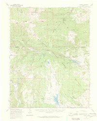
Editions of this 1967 Jasper Map
2 editions found
Other maps of this area

1913 · Summitville
USGS Topo · 1:125,000

1914 · Creede
USGS Topo · 1:125,000

1915 · Summitville
USGS Topo · 1:125,000

1915 · Del Norte
USGS Topo · 1:125,000

1916 · Creede
USGS Topo · 1:125,000

1917 · Del Norte
USGS Topo · 1:125,000

1922 · Conejos
USGS Topo · 1:125,000

1945 · Durango
USGS Topo · 1:250,000

1953 · Durango
USGS Topo · 1:250,000

1954 · Durango
USGS Topo · 1:250,000