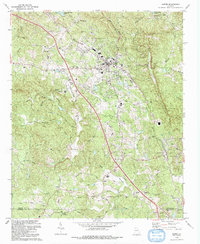
1992 Map of Jasper
USGS Topo · Published 1993About this map
The mountain town of Jasper serves as the focal point for this 1990s-era survey, revealing a landscape defined by its marble industry and expanding infrastructure. The Louisville and Nashville railroad tracks parallel the main thoroughfares, connecting the industrial quarries near Tate and Nelson to the broader regional market. Local landmarks like the Vocational Technical Sch and the Radio Tower (WYYZ) highlight the area's development as a county hub.
Find a feature on this map
70 named features on this map. Tap any name to fly to it.
Don’t see what you’re looking for? This feature index may not catch every label — zoom into the map to look around manually.
Map Details
Editions of this 1992 Jasper Map
This is the sole edition of this map. No revisions or reprints were ever made.
Other maps of this area

1886 · Dalton
USGS Topo · 1:125,000

1888 · Ellijay
USGS Topo · 1:125,000

1890 · Suwanee
USGS Topo · 1:125,000

1890 · Cartersville
USGS Topo · 1:125,000

1891 · Cartersville
USGS Topo · 1:125,000

1892 · Ellijay
USGS Topo · 1:125,000

1892 · Dalton
USGS Topo · 1:125,000

1894 · Suwanee
USGS Topo · 1:125,000

1896 · Cartersville
USGS Topo · 1:125,000

1897 · Dalton
USGS Topo · 1:125,000