
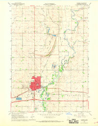
1967 Map of Jasper SE
USGS Topo · Published 1968About this map
Agricultural townships in the late 1960s define the landscape of this Rock County region, where the Chicago Rock Island and Pacific railroad cuts through the northeastern corner near the Pipestone County line. The map reveals a rural community structured around local institutions like Eden Ch, Rose Dell Ch, and the Rose Dell Cem. While most of the terrain is dedicated to farming across Rose Dell and Denver townships, small-scale industrial activity is evident at the Sandpit and Gravel Pit. Drainage for the region is provided by the winding paths of Beaver Creek and Poplar Creek. This survey includes unique details such as fine red dashed lines that indicate specific fence and field lines visible from 1965 aerial photography, offering a precise view of mid-century land use and property boundaries.
Find a feature on this map
18 named features on this map. Tap any name to fly to it.
Don’t see what you’re looking for? This feature index may not catch every label — zoom into the map to look around manually.
Map Details
Editions of this 1967 Jasper SE Map
This is the sole edition of this map. No revisions or reprints were ever made.
Other maps of this area

1955 · Sioux Falls
USGS Topo · 1:250,000

1958 · Sioux Falls
USGS Topo · 1:250,000

1967 · Edgerton South
USGS Topo · 1:24,000

1967 · Edgerton North
USGS Topo · 1:24,000

1967 · Garretson East
USGS Topo · 1:24,000

1967 · Hills NE
USGS Topo · 1:24,000

1967 · Pipestone South
USGS Topo · 1:24,000

1967 · Jasper
USGS Topo · 1:24,000

1967 · Jasper NW
USGS Topo · 1:24,000
1967 · Luverne
USGS Topo · 1:24,000