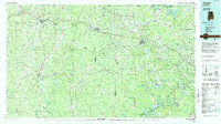
1984 Map of Jasper
USGS Topo · Published 1985About this map
Jasper serves as the focal point for this 1980s-era map of the Alabama coalfields, showing a landscape defined by industrial rail networks and the impounded waters of the Black Warrior River basin. The Burlington Northern and Southern railroads intersect at this hub, linking mining and timber communities like Carbon Hill, Parrish, and Cordova to the wider region. To the south, the expansion of Bankhead Lake and the industrial facilities at Port Birmingham highlight the river's role in heavy transport.
Find a feature on this map
73 named features on this map. Tap any name to fly to it.
Don’t see what you’re looking for? This feature index may not catch every label — zoom into the map to look around manually.
Map Details
Editions of this 1984 Jasper Map
2 editions found
Other maps of this area

1888 · Cullman
USGS Topo · 1:125,000

1889 · Birmingham
USGS Topo · 1:125,000

1890 · Bessemer
USGS Topo · 1:125,000

1892 · Cullman
USGS Topo · 1:125,000

1892 · Birmingham
USGS Topo · 1:125,000

1892 · Bessemer
USGS Topo · 1:125,000

1893 · Jasper
USGS Topo · 1:125,000

1895 · Birmingham
USGS Topo · 1:125,000

1899 · Brookwood
USGS Topo · 1:125,000

1904 · Birmingham Coal District
USGS Topo · 1:62,500