
1947 Map of Jayuya SO
USGS Topo · Published 1947About this map
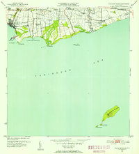
The high ridges of the Cordillera Central define this 1940s landscape, which centers on the dramatic elevation of Cerro de Punta. This preliminary topographic study, commissioned by Orlando R. Mendez for the Gobierno de Puerto Rico, documents the agrarian structure of the region where the boundary of Jayuya and Ponce meets.
Find a feature on this map
17 named features on this map. Tap any name to fly to it.
Don’t see what you’re looking for? This feature index may not catch every label — zoom into the map to look around manually.
Map Details
Editions of this 1947 Jayuya SO Map
This is the sole edition of this map. No revisions or reprints were ever made.
Historical Maps of Veguitas Through Time
19 maps found

1945 Playa De Ponce
Ponce Municipio, PR

1946 Punta Cuchara
Ponce Municipio, PR

1947 Adjuntas SE
Ponce Municipio, PR
1947 Jayuya SO
Ponce Municipio, PR

1947 Penuelas NE
Ponce Municipio, PR

1947 Penuelas SE
Ponce Municipio, PR

1947 Playa De Ponce NO
Ponce Municipio, PR

1947 Ponce NO
Ponce Municipio, PR

1947 Ponce SO
Ponce Municipio, PR

1947 Punta Gughara NE
Ponce Municipio, PR
1952 Playa De Ponce
Ponce Municipio, PR

1952 Punta Cuchara
Ponce Municipio, PR

1958 Playa De Ponce
Ponce Municipio, PR

1958 Punta Cucharas
Ponce Municipio, PR

1962 Playa De Ponce
Ponce Municipio, PR
1962 Punta Cucharas
Ponce Municipio, PR
1970 Playa De Ponce
Ponce Municipio, PR

2024 Playa De Ponce
Ponce Municipio, PR

2024 Punta Cucharas
Ponce Municipio, PR