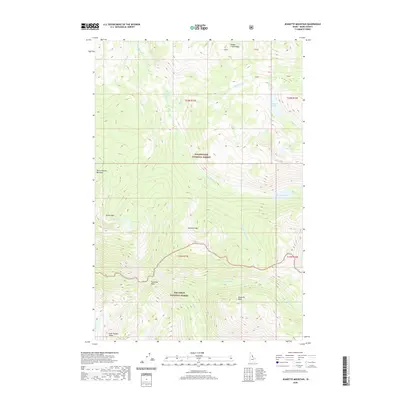
2020 Map of Jeanette Mountain
USGS Topo · Published 2020About this map
Clearwater National Forest and Nez Perce National Forest meet in this 2020 map, where high-elevation landmarks define the Idaho wilderness. The map details a landscape of significant peaks including Jeanette Mtn, Diablo Mtn, and the distinctive Goat Heaven Peaks in the southwest. A series of alpine waters like Hidden Lake, Corky Lake, and Big Sand Lake are situated among the ridges, feeding a complex drainage system that includes Big Sand Cr and Little Dead Elk Cr. This modern survey traces the boundary between two massive national forests across township lines like t35n r15e and t34n r15e. The presence of named landmarks such as Footstool Point and Horse Heaven Meadows suggests a history of local navigation and land use by early forest rangers or hunters in this interior portion of Idaho County.
Find a feature on this map
27 named features on this map. Tap any name to fly to it.
Don’t see what you’re looking for? This feature index may not catch every label — zoom into the map to look around manually.
Map Details
Editions of this 2020 Jeanette Mountain Map
This is the sole edition of this map. No revisions or reprints were ever made.
Other maps of this area

1901 · Hamilton
USGS Topo · 1:125,000

1911 · Lolo
USGS Topo · 1:250,000

1913 · Lolo
USGS Topo · 1:250,000

1956 · Hamilton
USGS Topo · 1:250,000

1959 · Hamilton
USGS Topo · 1:250,000

1960 · Hamilton
USGS Topo · 1:250,000

1964 · Hamilton
USGS Topo · 1:250,000

1964 · Tenmile Lake
USGS Topo · 1:24,000

1966 · Grave Peak
USGS Topo · 1:24,000
1966 · Wahoo Peak
USGS Topo · 1:24,000