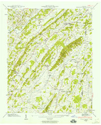
1939 Map of Jearoldstown
USGS Topo · Published 1960About this map
Jearoldstown and the surrounding hill country of the Greene and Washington County line are documented in this late 1930s survey. The landscape is defined by the corrugated ridges of the Graysburg Hills and Quaker Knobs, where small agricultural settlements are connected by the route of State Highway 93. These communities supported a network of local institutions, including the Union Temple Ch and Bethesda Ch, along with essential regional infrastructure such as the Clear Creek Mill and Eagle Mill.
Find a feature on this map
91 named features on this map. Tap any name to fly to it.
Don’t see what you’re looking for? This feature index may not catch every label — zoom into the map to look around manually.
Map Details
Editions of this 1939 Jearoldstown Map
3 editions found
Other maps of this area

1892 · Greeneville
USGS Topo · 1:125,000

1896 · Greeneville
USGS Topo · 1:125,000

1904 · Greeneville
USGS Topo · 1:125,000

1935 · Surgoinsville
USGS Topo · 1:48,000

1935 · Baileyton
USGS Topo · 1:24,000

1935 · Lovelace
USGS Topo · 1:24,000

1935 · Sullivan Gardens
USGS Topo · 1:24,000

1935 · Leesburg
USGS Topo · 1:24,000
1935 · Stonypoint
USGS Topo · 1:24,000

1935 · Fall Branch
USGS Topo · 1:48,000