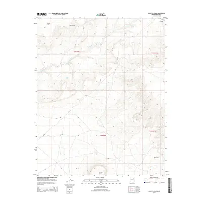
2014 Map of Jeddito Spring
USGS Topo · Published 2014About this map
Antelope Mesa and the prominent rising form of Stephen Butte define this high-desert landscape in northeastern Arizona. The area is marked by the winding course of Jeddito Wash, which cuts across the northern terrain near the settlement of Jeddito. Water sources are critical landmarks here, with both Jeddito Spring and Sand Spring noted in an otherwise arid expanse. The map illustrates a remote network of Bureau of Indian Affairs routes, including Bia-9102 and Bia-9759, which connect dispersed homesteads and the southern community of Whitecone. This 2014 survey documents the enduring geography of the Kawaika-A area, showing how modern transportation follows the natural contours of the mesas and washes that have shaped travel for generations.
Find a feature on this map
16 named features on this map. Tap any name to fly to it.
Don’t see what you’re looking for? This feature index may not catch every label — zoom into the map to look around manually.
Map Details
Editions of this 2014 Jeddito Spring Map
This is the sole edition of this map. No revisions or reprints were ever made.
Other maps of this area

1883 · Tusayan
USGS Topo · 1:250,000

1886 · Tusayan
USGS Topo · 1:250,000

1947 · Flagstaff
USGS Topo · 1:250,000

1954 · Flagstaff
USGS Topo · 1:250,000

1958 · Flagstaff
USGS Topo · 1:250,000

1960 · Flagstaff
USGS Topo · 1:250,000

1962 · Flagstaff
USGS Topo · 1:250,000

1966 · White Cone
USGS Topo · 1:62,500

1966 · Egloffstein Butte
USGS Topo · 1:62,500
1966 · Keams Canyon
USGS Topo · 1:62,500