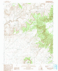
1991 Map of Jeddito Spring
USGS Topo · Published 1991About this map
Antelope Mesa dominates the northern landscape of this region where the high desert terrain is carved by the winding Jeddito Wash. This 1991 provisional survey captures a territory defined by the overlapping boundaries of the Hopi Indian Reservation and the Navajo Indian Reservation. The map records essential water sources in an arid environment, from the namesake Jeddito Spring to the more remote Indian Spring and Sand Spring. To the south, the prominent volcanic form of Stephen Butte rises sharply from the plains, serving as a significant landmark for the surrounding rangeland. The presence of Lamb Well and scattered unimproved roads indicates a landscape utilized primarily for grazing and traditional land use, as it remained largely undeveloped into the late twentieth century.
Find a feature on this map
9 named features on this map. Tap any name to fly to it.
Don’t see what you’re looking for? This feature index may not catch every label — zoom into the map to look around manually.
Map Details
Editions of this 1991 Jeddito Spring Map
This is the sole edition of this map. No revisions or reprints were ever made.
Other maps of this area

1883 · Tusayan
USGS Topo · 1:250,000

1886 · Tusayan
USGS Topo · 1:250,000

1947 · Flagstaff
USGS Topo · 1:250,000

1954 · Flagstaff
USGS Topo · 1:250,000

1958 · Flagstaff
USGS Topo · 1:250,000

1960 · Flagstaff
USGS Topo · 1:250,000

1962 · Flagstaff
USGS Topo · 1:250,000

1966 · White Cone
USGS Topo · 1:62,500

1966 · Egloffstein Butte
USGS Topo · 1:62,500
1966 · Keams Canyon
USGS Topo · 1:62,500