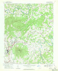
1968 Map of Jefferson
USGS Topo · Published 1971About this map
The confluence of the North Fork New River and South Fork New River characterizes this landscape in Ashe County. The twin hubs of Jefferson and West Jefferson serve as the primary centers of commerce and community, with Mount Jefferson State Park rising prominently between them. The mountain is topped by the Mount Jefferson Lookout Tower, a key vantage point for the surrounding highlands.
Find a feature on this map
58 named features on this map. Tap any name to fly to it.
Don’t see what you’re looking for? This feature index may not catch every label — zoom into the map to look around manually.
Map Details
Editions of this 1968 Jefferson Map
This is the sole edition of this map. No revisions or reprints were ever made.
Other maps of this area

1889 · Wytheville
USGS Topo · 1:125,000

1889 · Wilkesboro
USGS Topo · 1:125,000

1891 · Abingdon
USGS Topo · 1:125,000

1891 · Wilkesboro
USGS Topo · 1:125,000

1892 · Wytheville
USGS Topo · 1:125,000

1893 · Cranberry
USGS Topo · 1:125,000

1894 · Abingdon
USGS Topo · 1:125,000

1895 · Cranberry
USGS Topo · 1:125,000

1899 · Cranberry
USGS Topo · 1:125,000

1902 · Cranberry
USGS Topo · 1:125,000