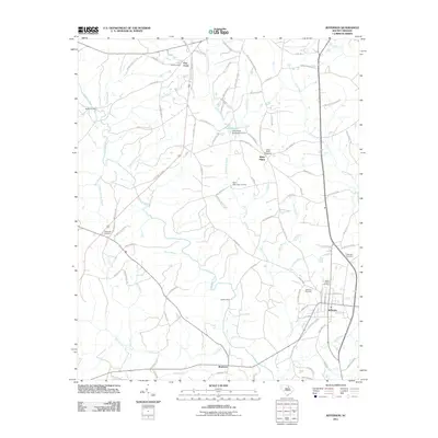
2011 Map of Jefferson
USGS Topo · Published 2011About this map
Jefferson serves as the primary hub in this South Carolina Piedmont landscape, where the town's residential grid meets several local routes like State Hwy S-13-39. For genealogists, the map is particularly detailed, identifying numerous burial sites such as the Miller-Lowery Cemetery, Jefferson Cemetery, and Hopewell Cemetery surrounding the central settlement. To the west, the Lynches River carves a winding path through the terrain, joined by tributaries like Shop Branch and Arant Branch.
Find a feature on this map
101 named features on this map. Tap any name to fly to it.
Don’t see what you’re looking for? This feature index may not catch every label — zoom into the map to look around manually.
Map Details
Editions of this 2011 Jefferson Map
This is the sole edition of this map. No revisions or reprints were ever made.
Other maps of this area

1941 · Spartanburg
USGS Topo · 1:250,000

1953 · Spartanburg
USGS Topo · 1:250,000

1960 · Spartanburg
USGS Topo · 1:250,000

1963 · Spartanburg
USGS Topo · 1:250,000

1964 · Spartanburg
USGS Topo · 1:250,000

1967 · Angelus
USGS Topo · 1:24,000

1967 · Mount Pisgah
USGS Topo · 1:24,000

1968 · Jefferson
USGS Topo · 1:24,000

1968 · Jefferson NE
USGS Topo · 1:24,000
1969 · Kershaw
USGS Topo · 1:24,000