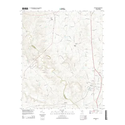
2014 Map of Jefferson
USGS Topo · Published 2014About this map
Jefferson anchors the southeastern corner of this map, appearing as a developed town center at the intersection of Us-601 and SC-265. The landscape is defined by the winding course of the Lynches River, which forms the boundary between Chesterfield Co and Lancaster Co. The area is notably dense with family-named landmarks and cemeteries, reflecting a long-standing rural community structure. Small settlements like White Plains, Five Forks, and Birdtown are connected by a network of local roads such as Takahaw Hwy and Ralph Hicks Rd. Genealogists will find significant value in the distribution of burial sites, including the Miller-Lowery Cem, White Plains Cem, and Five Fork Cem. Historical crossing points along the river, like McManns Ford and Griffins Ford, indicate where early commerce and travel dictated the local geography before modern bridges predominated.
Find a feature on this map
106 named features on this map. Tap any name to fly to it.
Don’t see what you’re looking for? This feature index may not catch every label — zoom into the map to look around manually.
Map Details
Editions of this 2014 Jefferson Map
This is the sole edition of this map. No revisions or reprints were ever made.
Other maps of this area

1941 · Spartanburg
USGS Topo · 1:250,000

1953 · Spartanburg
USGS Topo · 1:250,000

1960 · Spartanburg
USGS Topo · 1:250,000

1963 · Spartanburg
USGS Topo · 1:250,000

1964 · Spartanburg
USGS Topo · 1:250,000

1967 · Angelus
USGS Topo · 1:24,000

1967 · Mount Pisgah
USGS Topo · 1:24,000

1968 · Jefferson
USGS Topo · 1:24,000

1968 · Jefferson NE
USGS Topo · 1:24,000
1969 · Kershaw
USGS Topo · 1:24,000