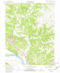
1962 Map of Jefferson City NW
USGS Topo · Published 1982About this map
The Missouri-Kansas-Texas and Missouri Pacific railroads parallel the northern bank of the Missouri River, defining the industrial and transit corridor between Boone and Callaway counties. This landscape is a mix of protected conservation lands and emerging residential development, with the University of Missouri maintaining the Ashland Wildlife Research Area in the north. Settlement is concentrated around Holts Summit and a nearby Trailer Park in the southeast, while the riverbottoms host the Renz Correction Center.
Find a feature on this map
38 named features on this map. Tap any name to fly to it.
Don’t see what you’re looking for? This feature index may not catch every label — zoom into the map to look around manually.
Map Details
Editions of this 1962 Jefferson City NW Map
This is the sole edition of this map. No revisions or reprints were ever made.
Other maps of this area

1886 · Jefferson City
USGS Topo · 1:125,000

1894 · Jefferson City
USGS Topo · 1:125,000

1939 · Jefferson City
USGS Topo · 1:24,000

1939 · Jefferson City
USGS Topo · 1:62,500

1942 · Jefferson City
USGS Topo · 1:62,500

1944 · Millersburg
USGS Topo · 1:62,500

1946 · Millersburg
USGS Topo · 1:62,500

1947 · Jefferson City
USGS Topo · 1:250,000

1948 · Centertown
USGS Topo · 1:62,500

1948 · Columbia
USGS Topo · 1:62,500