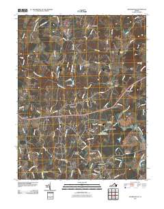
2010 Map of Jeffersonton
USGS Topo · Published 2010About this map
The Rappahannock River carves a winding path through this northern Virginia landscape, serving as a prominent geographical boundary for the communities of Jeffersonton and Amissville. By 2010, the area exhibits a blend of traditional agricultural crossroads and modern residential development, visible in the sprawl of Deerfield Estates and South Wales. The map documents several important local landmarks that speak to the region's transport and industrial history, such as the Waterloo Bridge and Cliff Mills.
Find a feature on this map
93 named features on this map. Tap any name to fly to it.
Don’t see what you’re looking for? This feature index may not catch every label — zoom into the map to look around manually.
Map Details
Editions of this 2010 Jeffersonton Map
This is the sole edition of this map. No revisions or reprints were ever made.
Other maps of this area

1893 · Luray
USGS Topo · 1:125,000

1894 · Warrenton
USGS Topo · 1:125,000

1894 · Warrenton
USGS Topo · 1:62,500

1905 · Luray
USGS Topo · 1:125,000

1927 · Remington
USGS Topo · 1:48,000

1930 · Warrenton
USGS Topo · 1:62,500

1939 · Front Royal
USGS Topo · 1:48,000

1943 · Orlean
USGS Topo · 1:24,000

1943 · Marshall
USGS Topo · 1:24,000
1944 · Marshall
USGS Topo · 1:31,680