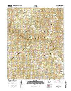
2016 Map of Jeffersonton
USGS Topo · Published 2016About this map
The Rappahannock River serves as a winding natural boundary for three Virginia counties, bisecting a landscape defined by historic crossings and high ground. Near the center of the map, the Waterloo Bridge connects the settlement of Waterloo across the river, while several small communities like Palmers Crossroads and Cliff Mills dot the northern terrain in Fauquier County. The topography is marked by distinct summits such as Piney Mtn and Black Hill, which overlook a network of creeks and runs including Carter Run and Negro Run.
Find a feature on this map
145 named features on this map. Tap any name to fly to it.
Don’t see what you’re looking for? This feature index may not catch every label — zoom into the map to look around manually.
Map Details
Editions of this 2016 Jeffersonton Map
This is the sole edition of this map. No revisions or reprints were ever made.
Other maps of this area

1893 · Luray
USGS Topo · 1:125,000

1894 · Warrenton
USGS Topo · 1:125,000

1894 · Warrenton
USGS Topo · 1:62,500

1905 · Luray
USGS Topo · 1:125,000

1927 · Remington
USGS Topo · 1:48,000

1930 · Warrenton
USGS Topo · 1:62,500

1939 · Front Royal
USGS Topo · 1:48,000

1943 · Orlean
USGS Topo · 1:24,000

1943 · Marshall
USGS Topo · 1:24,000
1944 · Marshall
USGS Topo · 1:31,680