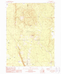
1990 Map of Jellico
USGS Topo · Published 1990About this map
The Lassen National Forest terrain in northeastern California dominates this 1990 survey, showing a landscape defined by volcanic landforms and managed water resources. At the southern edge of the map, the Cone and Ward Ranch sits near the headwaters of Butte Creek, which flows through the heart of the quadrangle. The topography is marked by named elevations such as Negro Camp Mountain and Ladder Butte, interspersed with various reservoirs including Freebee Reservoir and Bootleg Reservoir. High-altitude flats like Sheep Flat and Halls Flat provide rare level ground within the complex relief. Small seasonal locations and former activity sites, such as the Butte Camp (Site) and Jelly Camp, suggest the area's history of logging or grazing, while the presence of the R I M Road and several springs like Ericksons Spring indicate established backcountry access routes.
Find a feature on this map
31 named features on this map. Tap any name to fly to it.
Don’t see what you’re looking for? This feature index may not catch every label — zoom into the map to look around manually.
Map Details
Editions of this 1990 Jellico Map
This is the sole edition of this map. No revisions or reprints were ever made.
Other maps of this area

1886 · Lassen Peak
USGS Topo · 1:250,000

1892 · Lassen Peak
USGS Topo · 1:250,000

1894 · Lassen Peak
USGS Topo · 1:250,000

1939 · Halls Flat
USGS Topo · 1:125,000

1955 · Westwood
USGS Topo · 1:250,000

1956 · Harvey Mtn
USGS Topo · 1:62,500

1957 · Prospect Peak
USGS Topo · 1:62,500

1957 · Little Valley
USGS Topo · 1:62,500

1957 · Jellico
USGS Topo · 1:62,500

1958 · Westwood
USGS Topo · 1:250,000