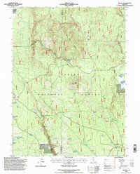
1995 Map of Jellico
USGS Topo · Published 1997About this map
Negro Camp Mountain and the volcanic terrain of Ladder Butte dominate this landscape within the Lassen National Forest during the mid-1990s. The settlement of Jellico sits along the Union Pacific rail line, which cuts through the high country where the borders of Shasta and Lassen counties meet. This area is defined by its extensive water management and ranching history, evidenced by numerous man-made features such as Beaver Creek Reservoir, Porcupine Reservoir, and the Cone and Ward Ranch.
Find a feature on this map
34 named features on this map. Tap any name to fly to it.
Don’t see what you’re looking for? This feature index may not catch every label — zoom into the map to look around manually.
Map Details
Editions of this 1995 Jellico Map
This is the sole edition of this map. No revisions or reprints were ever made.
Other maps of this area

1886 · Lassen Peak
USGS Topo · 1:250,000

1892 · Lassen Peak
USGS Topo · 1:250,000

1894 · Lassen Peak
USGS Topo · 1:250,000

1939 · Halls Flat
USGS Topo · 1:125,000

1955 · Westwood
USGS Topo · 1:250,000

1956 · Harvey Mtn
USGS Topo · 1:62,500

1957 · Prospect Peak
USGS Topo · 1:62,500

1957 · Little Valley
USGS Topo · 1:62,500

1957 · Jellico
USGS Topo · 1:62,500

1958 · Westwood
USGS Topo · 1:250,000