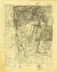
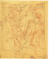
1892 Map of Jemez
USGS Topo · Published 1910About this map
Jemez Pueblo and the surrounding ancestral lands occupy the heart of this landscape, as documented by Henry Gannett and the U.S. Geological Survey at the turn of the century. The map illustrates a complex geography of land grants and reservations, including the Baca Location and the Jemez Indian Reservation, set against the dramatic elevation of Redondo Peak. Key water sources such as Jemez Creek and the Rio Salado provide the lifeline for early settlements like San Ysidro and Zia.
Find a feature on this map
30 named features on this map. Tap any name to fly to it.
Don’t see what you’re looking for? This feature index may not catch every label — zoom into the map to look around manually.
Map Details
Editions of this 1892 Jemez Map
4 editions found

Other maps of this area

1883 · Mt. Taylor
USGS Topo · 1:250,000

1886 · Mt. Taylor
USGS Topo · 1:250,000

1888 · Bernalillo
USGS Topo · 1:125,000

1889 · Albuquerque
USGS Topo · 1:125,000

1889 · Largo
USGS Topo · 1:250,000

1890 · Jemes
USGS Topo · 1:125,000

1892 · San Pedro
USGS Topo · 1:125,000

1892 · Jemes
USGS Topo · 1:125,000

1892 · Santa Clara
USGS Topo · 1:125,000

1892 · Mt. Taylor
USGS Topo · 1:250,000