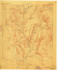
1892 Map of Jemez
USGS Topo · Published 1910About this map
The Sierra Nacimiento dominates this high-altitude landscape, where the Canyon Guadalupe and Canyon San Diego converge to form the upper reaches of Jemez Creek. Surveyed in the late 1880s, the map illustrates a network of isolated outposts and springs vital to regional travel and early resource extraction. The presence of the San Miguel Mine near La Ventana and the established settlements at Jemez Springs and Sulphur Springs reflect an era of geothermal and mineral exploration. Several "Ojos" or springs, including Ojo del Espiritu Santo and Ojo Chamisa, serve as critical landmarks across the arid terrain. To the south, the village of San Ysidro marks a key junction near the Rio Salado, while the high valleys of Valle San Antonio and Vallecito Viejo suggest the high-country pastoral activities that defined the border between Bernalillo and Rio Arriba counties at the turn of the century.
Find a feature on this map
30 named features on this map. Tap any name to fly to it.
Don’t see what you’re looking for? This feature index may not catch every label — zoom into the map to look around manually.
Map Details
Editions of this 1892 Jemez Map
4 editions found
Other maps of this area

1883 · Mt. Taylor
USGS Topo · 1:250,000

1886 · Mt. Taylor
USGS Topo · 1:250,000

1888 · Bernalillo
USGS Topo · 1:125,000

1889 · Albuquerque
USGS Topo · 1:125,000

1889 · Largo
USGS Topo · 1:250,000

1890 · Jemes
USGS Topo · 1:125,000

1892 · San Pedro
USGS Topo · 1:125,000

1892 · Jemes
USGS Topo · 1:125,000

1892 · Santa Clara
USGS Topo · 1:125,000

1892 · Mt. Taylor
USGS Topo · 1:250,000