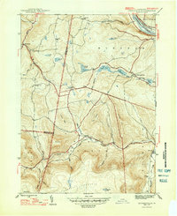
1947 Map of Jenningsville
USGS Topo · Published 1947About this map
Mehoopany Creek and the North Fork Mehoopany Creek converge at the village of Forkston, anchoring a landscape of steep ridges and small farming settlements in Wyoming County. This mid-century survey captures the region's rural character, where local education was still centered on country schoolhouses like Sugar Hill Sch, Golden Hill Sch, and Grant Hill Sch. Along the northern edge, the Susquehanna River serves as a vital transit corridor, carrying the Lehigh Valley railroad and the Roosevelt Highway through the township of Braintrim.
Find a feature on this map
49 named features on this map. Tap any name to fly to it.
Don’t see what you’re looking for? This feature index may not catch every label — zoom into the map to look around manually.
Map Details
Editions of this 1947 Jenningsville Map
2 editions found

Other maps of this area

1891 · Harveys Lake
USGS Topo · 1:62,500

1893 · Harvey Lake
USGS Topo · 1:62,500

1934 · Laporte
USGS Topo · 1:62,500

1943 · Monroeton
USGS Topo · 1:62,500

1945 · Meshoppen
USGS Topo · 1:62,500

1945 · Auburn Center
USGS Topo · 1:24,000

1945 · Jenningsville
USGS Topo · 1:24,000

1945 · Meshoppen
USGS Topo · 1:24,000

1945 · Laceyville
USGS Topo · 1:24,000

1946 · Dutch Mtn
USGS Topo · 1:24,000
Featured Places
- Wilmot Township, PA
- Colley Township, PA
- Forkston Township, PA
- Lovelton, North Branch Township
- North Branch Township, PA