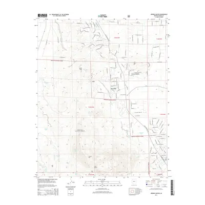
2014 Map of Jerome Canyon
USGS Topo · Published 2014About this map
Williamson and the smaller settlements of Mint and Stringfield anchor this portion of Yavapai County, where residential development meets the protected landscapes of the Prescott National Forest. The terrain is defined by dramatic elevations, including Granite Mountain and Table Mountain, which overlook a network of seasonal drainages such as Mint Wash and Cooper Wash. The map reveals a transition from the established street grids of the northern valleys to the more sparsely populated ranch and forest lands to the south. Local water sources, crucial in this arid environment, are mapped in detail, ranging from named tanks like Shroder Tank to numerous springs including Baker Spring, Tin Trough Spring, and Alkali Spring. For those interested in the area's geography, the topographic data highlights significant natural passages like Blair Pass and the winding course of Jerome Canyon.
Find a feature on this map
142 named features on this map. Tap any name to fly to it.
Don’t see what you’re looking for? This feature index may not catch every label — zoom into the map to look around manually.
Map Details
Editions of this 2014 Jerome Canyon Map
This is the sole edition of this map. No revisions or reprints were ever made.
Other maps of this area

1887 · Prescott
USGS Topo · 1:250,000

1892 · Prescott
USGS Topo · 1:250,000

1905 · Jerome
USGS Topo · 1:125,000

1947 · Simmons
USGS Topo · 1:62,500

1947 · Iron Springs
USGS Topo · 1:62,500

1947 · Paulden
USGS Topo · 1:62,500

1947 · Prescott
USGS Topo · 1:62,500

1948 · Iron Springs
USGS Topo · 1:63,360

1948 · Prescott
USGS Topo · 1:62,500

1948 · Simmons
USGS Topo · 1:63,360