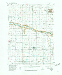
1950 Map of Jerome
USGS Topo · Published 1959About this map
The Snake River carves a deep canyon through this landscape, creating a dramatic boundary between the irrigation-dependent farmlands of the Magic Valley. The northern bank is anchored by Jerome, showing a growing town center adjacent to the State Game Farm and the Union Pacific railroad line. Along the river's edge, several natural landmarks such as Niagara Springs, Crystal Sprs, and Auger Falls highlight the unique hydrology of the Snake River Plain.
Find a feature on this map
54 named features on this map. Tap any name to fly to it.
Don’t see what you’re looking for? This feature index may not catch every label — zoom into the map to look around manually.
Map Details
Editions of this 1950 Jerome Map
2 editions found
Other maps of this area

1949 · Thousand Springs
USGS Topo · 1:24,000

1949 · Tuttle
USGS Topo · 1:24,000

1950 · Niagara Springs
USGS Topo · 1:24,000

1950 · Filer
USGS Topo · 1:24,000

1950 · Jerome
USGS Topo · 1:24,000

1950 · Jerome
USGS Topo · 1:62,500

1951 · Thousand Springs
USGS Topo · 1:24,000

1951 · Tuttle
USGS Topo · 1:24,000

1951 · Clover
USGS Topo · 1:24,000

1954 · Thousand Springs
USGS Topo · 1:24,000