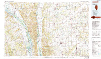
1985 Map of Jerseyville
USGS Topo · Published 1985About this map
Jerseyville and the agricultural lands of Jersey County serve as the eastern anchor for this mid-1980s landscape, where the flat upland prairies meet the dramatic bluff lines of the Mississippi River and Illinois River. The map captures a complex riverine environment of backwater sloughs and islands, much of it protected within the Clarence Cannon National Wildlife Refuge and the Mark Twain National Wildlife Refuge. These bottomlands contrast sharply with the dissected ridges of Hurricane Ridge and Burr Oak Ridge.
Find a feature on this map
164 named features on this map. Tap any name to fly to it.
Don’t see what you’re looking for? This feature index may not catch every label — zoom into the map to look around manually.
Map Details
Editions of this 1985 Jerseyville Map
2 editions found
Other maps of this area

1890 · Louisiana
USGS Topo · 1:125,000

1890 · Hermann
USGS Topo · 1:125,000

1903 · O'Fallon
USGS Topo · 1:125,000

1912 · Gillespie
USGS Topo · 1:62,500

1915 · Gillespie
USGS Topo · 1:62,500

1923 · Carlinville
USGS Topo · 1:48,000

1924 · Winchester
USGS Topo · 1:48,000

1924 · Waverly
USGS Topo · 1:62,500

1924 · Roodhouse
USGS Topo · 1:62,500

1924 · Griggsville
USGS Topo · 1:62,500