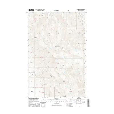
2014 Map of Jewel Basin
USGS Topo · Published 2014About this map
The Swan Range dominates this portion of the Flathead National Forest, where the high-altitude terrain of the Jewel Basin contains numerous glacial lakes. This 2014 survey captures a landscape defined by dramatic vertical relief, from the peak of Mt Aeneas to the depressions holding Birch Lake, Martha Lake, and the Picnic Lakes. The presence of Jewel Basin Rd and Noisy Creek Rd indicates the primary access routes into these backcountry areas, which are noted for their lack of permanent settlements. Near the southwestern corner, the northern edge of Bigfork appears as the only established community, contrasting with the remote ridges of Pioneer Ridge and Tongue Mtn. Water drainage patterns are clearly defined by the paths of Wounded Buck Cr and Wildcat Cr, which flow through the mountain passes towards the valley floor.
Find a feature on this map
59 named features on this map. Tap any name to fly to it.
Don’t see what you’re looking for? This feature index may not catch every label — zoom into the map to look around manually.
Map Details
Editions of this 2014 Jewel Basin Map
This is the sole edition of this map. No revisions or reprints were ever made.
Other maps of this area

1914 · Nyack
USGS Topo · 1:125,000

1943 · Kalispell
USGS Topo · 1:125,000

1957 · Kalispell
USGS Topo · 1:250,000

1960 · Kalispell
USGS Topo · 1:250,000

1960 · Cut Bank
USGS Topo · 1:250,000

1961 · Kalispell
USGS Topo · 1:250,000

1962 · Doris Mountain
USGS Topo · 1:24,000

1962 · Hash Mountain
USGS Topo · 1:24,000
1962 · Bigfork
USGS Topo · 1:24,000

1963 · Cut Bank
USGS Topo · 1:250,000