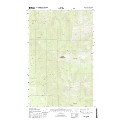
2017 Map of Jewel Basin
USGS Topo · Published 2017About this map
Jewel Basin and the surrounding heights of the Swan Range define this high-altitude landscape within the Flathead National Forest. This 2017 survey details a primitive backcountry environment dominated by steep topography and a dense network of glacial lakes and drainages. Major peaks including Mt Aeneas, Wildcat Mtn, and Strawberry Mtn rise above a series of remote water bodies such as Wildcat Lake, Strawberry Lake, and Aeneas Lake. The map shows limited human infrastructure, primarily centered on access routes like Jewell Basin Rd and Krause Basin Rd. The prevalence of named creeks like Wildcat Cr, Noisy Cr, and Graves Cr illustrates the complex hydrology of this mountainous terrain, where multiple lake chains including Picnic Lakes and Twin Lakes feed into the regional watershed.
Find a feature on this map
54 named features on this map. Tap any name to fly to it.
Don’t see what you’re looking for? This feature index may not catch every label — zoom into the map to look around manually.
Map Details
Editions of this 2017 Jewel Basin Map
This is the sole edition of this map. No revisions or reprints were ever made.
Other maps of this area

1914 · Nyack
USGS Topo · 1:125,000

1943 · Kalispell
USGS Topo · 1:125,000

1957 · Kalispell
USGS Topo · 1:250,000

1960 · Kalispell
USGS Topo · 1:250,000

1960 · Cut Bank
USGS Topo · 1:250,000

1961 · Kalispell
USGS Topo · 1:250,000

1962 · Doris Mountain
USGS Topo · 1:24,000

1962 · Hash Mountain
USGS Topo · 1:24,000
1962 · Bigfork
USGS Topo · 1:24,000

1963 · Cut Bank
USGS Topo · 1:250,000