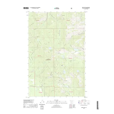
2020 Map of Jewel Basin
USGS Topo · Published 2020About this map
Flathead National Forest defines this high-elevation landscape in the Swan Range, where the steep slopes and glacial cirques of the Jewel Basin dominate the terrain. The survey highlights a dense network of alpine water bodies, from Aeneas Lake and Birch Lake to the uniquely named Lake Seven Acres and In-Uhl-am-keh Lake. High points such as Mt Aeneas, Strawberry Mtn, and Wildcat Mtn provide the literal backbone for the area's geography. Human presence is largely defined by recreational access, evidenced by the Alpine 7 trail and the trailhead at Camp Misery. This 2020 map documents the modern drainage patterns of Noisy Cr and Wounded Buck Cr, along with numerous Forest Service developments such as Natl Forest Develop Road 5339 Rd that provide entry into this protected wilderness.
Find a feature on this map
69 named features on this map. Tap any name to fly to it.
Don’t see what you’re looking for? This feature index may not catch every label — zoom into the map to look around manually.
Map Details
Editions of this 2020 Jewel Basin Map
This is the sole edition of this map. No revisions or reprints were ever made.
Other maps of this area

1914 · Nyack
USGS Topo · 1:125,000

1943 · Kalispell
USGS Topo · 1:125,000

1957 · Kalispell
USGS Topo · 1:250,000

1960 · Kalispell
USGS Topo · 1:250,000

1960 · Cut Bank
USGS Topo · 1:250,000

1961 · Kalispell
USGS Topo · 1:250,000

1962 · Doris Mountain
USGS Topo · 1:24,000

1962 · Hash Mountain
USGS Topo · 1:24,000
1962 · Bigfork
USGS Topo · 1:24,000

1963 · Cut Bank
USGS Topo · 1:250,000