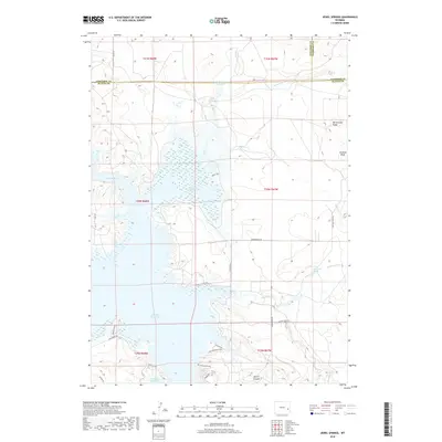
2018 Map of Jewel Springs
USGS Topo · Published 2018About this map
Glendo Reservoir dominates this landscape where Converse, Platte, and Niobrara counties converge. The reservoir, formed by the impoundment of the N Platte River, features an intricate shoreline characterized by numerous inlets and bays, particularly around the Muddy Gap area. This 2018 survey reveals a terrain defined by significant elevation changes, from the heights of Rattlesnake Ridge and Sentinel Rock to the depths of Morris Canyon. A network of unpaved roads and trails, such as Dune Trail and Narrows Bluff Trail, provides access to the remote back-country near Jewel Springs. The map also details smaller water features like Muddy Reservoir Number 1 and Buck Camp Spring, which are essential landmarks in this high-plains environment.
Find a feature on this map
38 named features on this map. Tap any name to fly to it.
Don’t see what you’re looking for? This feature index may not catch every label — zoom into the map to look around manually.
Map Details
Editions of this 2018 Jewel Springs Map
This is the sole edition of this map. No revisions or reprints were ever made.
Other maps of this area

1896 · Hartville
USGS Topo · 1:125,000

1901 · Hartville
USGS Topo · 1:125,000

1949 · Shawnee
USGS Topo · 1:24,000

1949 · Cedar Top
USGS Topo · 1:24,000

1950 · Glendo
USGS Topo · 1:24,000

1950 · Amend Ranch
USGS Topo · 1:24,000

1950 · Cedar Top
USGS Topo · 1:24,000

1950 · Prairie View School
USGS Topo · 1:24,000

1950 · Shawnee
USGS Topo · 1:24,000

1950 · Jewel Springs
USGS Topo · 1:24,000