
1950 Map of Shawnee
USGS Topo · Published 1950About this map
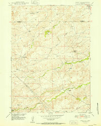
Chicago and Northwestern tracks cut a diagonal path across this high plains landscape, serving as the primary corridor for movement through Converse County. At the midpoint of the line sits Fisher, while the settlement of Shawnee anchors the northeastern corner near the confluence of local drainages. The topography is defined by the winding course of Shawnee Creek, which eventually gives way to the broader flow of the North Platte River in the southwest. This 1950 edition captures the area's transition into the mid-century, where the rail line remained a vital link between these small outposts. Scattered Windmill sites across the terrain indicate the reliance on groundwater for ranching and homesteading operations in this semi-arid region. The map also delineates the northern reaches of Lost Creek, providing a detailed look at the water-scarce environment before more modern development altered the land use patterns.
Find a feature on this map
9 named features on this map. Tap any name to fly to it.
Don’t see what you’re looking for? This feature index may not catch every label — zoom into the map to look around manually.
Map Details
Editions of this 1950 Shawnee Map
This is the sole edition of this map. No revisions or reprints were ever made.
Other maps of this area

1949 · Shawnee
USGS Topo · 1:24,000

1949 · Cedar Hill
USGS Topo · 1:24,000

1949 · Orin
USGS Topo · 1:24,000

1950 · Glendo
USGS Topo · 1:24,000

1950 · Amend Ranch
USGS Topo · 1:24,000

1950 · Orin
USGS Topo · 1:24,000

1950 · Jewel Springs
USGS Topo · 1:24,000
1951 · Cedar Hill
USGS Topo · 1:24,000

1954 · Torrington
USGS Topo · 1:250,000

1958 · Torrington
USGS Topo · 1:250,000