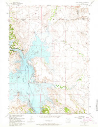
1961 Map of Jewel Springs
USGS Topo · Published 1965About this map
The North Platte River dominates the western portion of this 1961 landscape, where the waters of the Glendo Reservoir fill the valley to a normal pool elevation of 4635 feet. Established just years prior as part of the Missouri River Basin development, the reservoir and the adjacent Glendo State Park redefined the local topography, submerged portions of the riverbed, and created a new recreational center at the border of Platte and Converse counties. Stretching across the high plains to the east, the historic Emigrant Trail cuts a diagonal path through the terrain, providing a tangible link to the wagon routes that once traversed this region. Landforms such as Rattlesnake Ridge and Sentinel Rock overlook a network of seasonal drainages including Spanish Creek and Willow Creek, while localized water sources like Jewel Springs and Buck Camp Spring anchor the ranching landscape.
Find a feature on this map
19 named features on this map. Tap any name to fly to it.
Don’t see what you’re looking for? This feature index may not catch every label — zoom into the map to look around manually.
Map Details
Editions of this 1961 Jewel Springs Map
This is the sole edition of this map. No revisions or reprints were ever made.
Other maps of this area

1896 · Hartville
USGS Topo · 1:125,000

1901 · Hartville
USGS Topo · 1:125,000

1949 · Shawnee
USGS Topo · 1:24,000

1949 · Cedar Top
USGS Topo · 1:24,000

1950 · Glendo
USGS Topo · 1:24,000

1950 · Amend Ranch
USGS Topo · 1:24,000

1950 · Cedar Top
USGS Topo · 1:24,000

1950 · Prairie View School
USGS Topo · 1:24,000

1950 · Shawnee
USGS Topo · 1:24,000

1950 · Jewel Springs
USGS Topo · 1:24,000