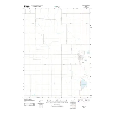
2010 Map of Jewell
USGS Topo · Published 2010About this map
Jewell serves as the primary hub of this Hamilton County landscape, situated where the grid of rural farm roads meets the more concentrated street plan of the town. This 2010 survey illustrates a region defined by agricultural drainage and significant glacial water bodies, including the prominent Little Wall Lake to the south and the smaller Goose Lake to the east. The presence of the Jewell Post Office and Evergreen Cemetery provides essential landmarks for family history research and local geocoding. The terrain is further shaped by water management features like the Grove Branch Ditch and the natural winding path of Keigley Branch in the southwest corner. The transition from high-density farming along routes like Neely Ave and Poplar Grove Ave to the residential pocket of the town illustrates the 21st-century agricultural character of central Iowa.
Find a feature on this map
28 named features on this map. Tap any name to fly to it.
Don’t see what you’re looking for? This feature index may not catch every label — zoom into the map to look around manually.
Map Details
Editions of this 2010 Jewell Map
This is the sole edition of this map. No revisions or reprints were ever made.
Other maps of this area

1912 · Ames
USGS Topo · 1:62,500

1914 · Ames
USGS Topo · 1:62,500

1916 · Boone
USGS Topo · 1:62,500

1954 · Waterloo
USGS Topo · 1:250,000

1955 · Waterloo
USGS Topo · 1:250,000

1965 · Mackey
USGS Topo · 1:24,000

1975 · Ames NW
USGS Topo · 1:24,000

1975 · Story City
USGS Topo · 1:24,000

1978 · Blairsburg
USGS Topo · 1:24,000

1978 · Ellsworth
USGS Topo · 1:24,000
Featured Places
- Jewell Junction, IA
- Jewell, Jewell Junction
- Clear Lake Township, IA
- Hamilton Township, IA
- Lyon Township, IA