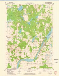
1975 Map of Jim Falls
USGS Topo · Published 1978About this map
The Chippewa River dominates this mid-1970s survey, serving as the industrial and geographic spine for the settlement at Jim Falls. The river's utility is marked by the presence of a Substa Powerplant and the extensive Old Abe Lake reservoir system. Inland from the riverbanks, the terrain is characterized by a dense network of glacial lakes including Cornell Lake, Jim Lake, and Popple Lake, many featuring public access points that underscore the area's transition into a recreation-friendly landscape. Evidence of the local economy is found in the scattered Gravel Pits and the Industrial Waste Ponds south of the main falls.
Find a feature on this map
48 named features on this map. Tap any name to fly to it.
Don’t see what you’re looking for? This feature index may not catch every label — zoom into the map to look around manually.
Map Details
Editions of this 1975 Jim Falls Map
This is the sole edition of this map. No revisions or reprints were ever made.
Other maps of this area

1934 · Chippewa Falls
USGS Topo · 1:62,500

1936 · Chippewa Falls
USGS Topo · 1:62,500

1949 · Bloomer
USGS Topo · 1:62,500

1951 · Bloomer
USGS Topo · 1:62,500

1951 · Cornell
USGS Topo · 1:62,500

1952 · Cadott
USGS Topo · 1:62,500

1953 · Eau Claire
USGS Topo · 1:250,000

1953 · Rice Lake
USGS Topo · 1:250,000

1958 · Eau Claire
USGS Topo · 1:250,000

1959 · Rice Lake
USGS Topo · 1:250,000