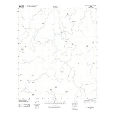
2010 Map of Jo Jan Van Camp
USGS Topo · Published 2010About this map
Jo Jan Van Camp sits amidst a network of deep drainage draws and named canyons in this part of Real County. The landscape is defined by its water sources, including Ice Waterhole, Cave Spring, and Lynn Spring, which are vital in this arid terrain. A series of ranch roads, such as Ranch Rd 2631 and Rim Rock Rd, wind through the topography, connecting the Flying Bull Ranch Airport to various hollows and draws.
Find a feature on this map
48 named features on this map. Tap any name to fly to it.
Don’t see what you’re looking for? This feature index may not catch every label — zoom into the map to look around manually.
Map Details
Editions of this 2010 Jo Jan Van Camp Map
This is the sole edition of this map. No revisions or reprints were ever made.
Other maps of this area

1893 · Nueces
USGS Topo · 1:125,000

1896 · Nueces
USGS Topo · 1:125,000

1944 · Barksdale
USGS Topo · 1:62,500

1947 · Hackberry
USGS Topo · 1:62,500

1954 · San Antonio
USGS Topo · 1:250,000

1957 · San Antonio
USGS Topo · 1:250,000

1957 · York Hollow
USGS Topo · 1:62,500

1958 · Del Rio
USGS Topo · 1:250,000

1964 · Del Rio
USGS Topo · 1:250,000
1971 · Leakey
USGS Topo · 1:24,000