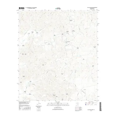
2016 Map of Jo Jan Van Camp
USGS Topo · Published 2016About this map
Vander Stucken Springs and the settlement of Jo Jan Van Camp anchor this landscape in the Edwards Plateau region of Real County. The terrain is defined by a dense network of canyons and draws, such as Javalina Canyon and Pecan Springs Draw, which channel seasonal water toward Bullhead Cr. Significant elevations including Turkey Peak, Echo Mtn, and Hog Pen Mtn rise above the surrounding flats and hollows. The presence of numerous named water sources like Ice Waterhole, Cord Spring, and Pletcher Lake suggests the importance of reliable water management in this arid ranching country. Transportation is provided by a web of local routes including Ranch Rd 2631, Satterfield Rd, and Mitchell Ranch Rd, which connect isolated homesteads and grazing lands across the limestone breaks.
Find a feature on this map
58 named features on this map. Tap any name to fly to it.
Don’t see what you’re looking for? This feature index may not catch every label — zoom into the map to look around manually.
Map Details
Editions of this 2016 Jo Jan Van Camp Map
This is the sole edition of this map. No revisions or reprints were ever made.
Other maps of this area

1893 · Nueces
USGS Topo · 1:125,000

1896 · Nueces
USGS Topo · 1:125,000

1944 · Barksdale
USGS Topo · 1:62,500

1947 · Hackberry
USGS Topo · 1:62,500

1954 · San Antonio
USGS Topo · 1:250,000

1957 · San Antonio
USGS Topo · 1:250,000

1957 · York Hollow
USGS Topo · 1:62,500

1958 · Del Rio
USGS Topo · 1:250,000

1964 · Del Rio
USGS Topo · 1:250,000
1971 · Leakey
USGS Topo · 1:24,000