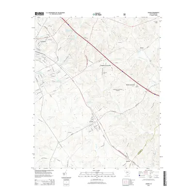
2014 Map of Joanna
USGS Topo · Published 2014About this map
The town of Joanna and the eastern outskirts of Clinton anchor this landscape along the Laurens and Newberry county line. The terrain is defined by the headwaters of the Bush River and Indian Creek, with a significant portion of the area preserved within the Sumter National Forest. Local history is visible through scattered rural settlements like Neighbors Crossroads, Bonds Crossroads, and Renno, alongside several family and community burial grounds including Rosemont Cemetery and Hurricane Cemetery. The map captures a mix of educational and infrastructure landmarks, from the campus of Presbyterian College to the Tip Top Lookout Tower standing at the edge of the forest. Numerous small bodies of water, such as Heath Copeland Pond and Sarah Copeland Pond, are interspersed among the drainages of South Fork Duncan Creek and Stillhouse Branch.
Find a feature on this map
109 named features on this map. Tap any name to fly to it.
Don’t see what you’re looking for? This feature index may not catch every label — zoom into the map to look around manually.
Map Details
Editions of this 2014 Joanna Map
This is the sole edition of this map. No revisions or reprints were ever made.
Other maps of this area

1941 · Spartanburg
USGS Topo · 1:250,000

1953 · Spartanburg
USGS Topo · 1:250,000

1960 · Spartanburg
USGS Topo · 1:250,000

1963 · Spartanburg
USGS Topo · 1:250,000

1964 · Spartanburg
USGS Topo · 1:250,000

1969 · Ora
USGS Topo · 1:24,000

1969 · Newberry NW
USGS Topo · 1:24,000

1969 · Sedalia
USGS Topo · 1:24,000
1969 · Philson Crossroads
USGS Topo · 1:24,000

1969 · Newberry West
USGS Topo · 1:24,000