
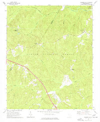
1969 Map of Newberry NW
USGS Topo · Published 1972About this map
Stomp Springs and a series of rural crossroads define this 1969 landscape where the Laurens and Newberry county lines meet. The terrain is deeply carved by a network of waterways including Indian Creek and Duncan Creek, much of which is protected within the Sumter National Forest. This era of the Piedmont shows a transition from traditional agricultural patterns to modern transportation corridors, with the Seaboard Coast Line railroad skirting the northern boundary while state highways intersect at local hubs like Brickhouse Crossroads and Eison Crossroads. Genealogists will find several rural centers of worship, such as Cedar Grove Ch and Zion Ch, which remained vital community anchors even as the larger settlement of Whitmire developed just beyond the northeast corner. The map also captures fine-grained details like Colonial Dr and a lone Rest Area along the modern highway.
Find a feature on this map
31 named features on this map. Tap any name to fly to it.
Don’t see what you’re looking for? This feature index may not catch every label — zoom into the map to look around manually.
Map Details
Editions of this 1969 Newberry NW Map
2 editions found
Other maps of this area

1941 · Spartanburg
USGS Topo · 1:250,000

1953 · Spartanburg
USGS Topo · 1:250,000

1960 · Spartanburg
USGS Topo · 1:250,000

1963 · Spartanburg
USGS Topo · 1:250,000

1964 · Spartanburg
USGS Topo · 1:250,000

1968 · Newberry East
USGS Topo · 1:24,000

1969 · Whitmire South
USGS Topo · 1:24,000

1969 · Sedalia
USGS Topo · 1:24,000
1969 · Philson Crossroads
USGS Topo · 1:24,000

1969 · Newberry West
USGS Topo · 1:24,000
Featured Places
- Stomp Springs, SC
- Eison Crossroads, SC
- Brickhouse Crossroads, SC
- Cromer Crossroads, SC
- Laurens County, SC