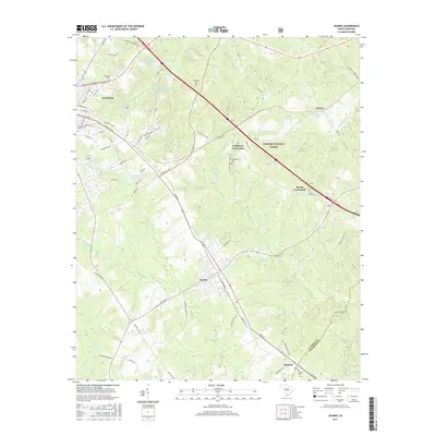
2017 Map of Joanna
USGS Topo · Published 2017About this map
The southeastern reaches of Clinton anchor this landscape, where the campus of Presbyterian Coll and the historic Rosemont Cem meet the rolling woodlands of the Sumter National Forest. Traveling southeast along the highway and rail corridors, the industrial character of Joanna is visible alongside the smaller rural junctions of Neighbors Crossroads and Bonds Crossroads. This map captures a classic Piedmont South Carolina settlement pattern, where small communities like Renno and Kinards emerged at the intersection of transport routes and agricultural lands.
Find a feature on this map
94 named features on this map. Tap any name to fly to it.
Don’t see what you’re looking for? This feature index may not catch every label — zoom into the map to look around manually.
Map Details
Editions of this 2017 Joanna Map
This is the sole edition of this map. No revisions or reprints were ever made.
Other maps of this area

1941 · Spartanburg
USGS Topo · 1:250,000

1953 · Spartanburg
USGS Topo · 1:250,000

1960 · Spartanburg
USGS Topo · 1:250,000

1963 · Spartanburg
USGS Topo · 1:250,000

1964 · Spartanburg
USGS Topo · 1:250,000

1969 · Ora
USGS Topo · 1:24,000

1969 · Newberry NW
USGS Topo · 1:24,000

1969 · Sedalia
USGS Topo · 1:24,000
1969 · Philson Crossroads
USGS Topo · 1:24,000

1969 · Newberry West
USGS Topo · 1:24,000