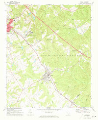
1971 Map of Joanna
USGS Topo · Published 1973About this map
Clinton anchors the western edge of this Piedmont landscape, appearing as a significant local hub during the early 1970s. The town's layout is defined by its educational and social institutions, including the campus of Presbyterian College and the large footprint of the Whitten Village State Training School. To the southeast, the mill town of Joanna sits along the Columbia Newberry and Laurens railroad line, surrounded by the wooded expanses of the Sumter National Forest.
Find a feature on this map
36 named features on this map. Tap any name to fly to it.
Don’t see what you’re looking for? This feature index may not catch every label — zoom into the map to look around manually.
Map Details
Editions of this 1971 Joanna Map
This is the sole edition of this map. No revisions or reprints were ever made.
Other maps of this area

1941 · Spartanburg
USGS Topo · 1:250,000

1953 · Spartanburg
USGS Topo · 1:250,000

1960 · Spartanburg
USGS Topo · 1:250,000

1963 · Spartanburg
USGS Topo · 1:250,000

1964 · Spartanburg
USGS Topo · 1:250,000

1969 · Ora
USGS Topo · 1:24,000

1969 · Newberry NW
USGS Topo · 1:24,000

1969 · Sedalia
USGS Topo · 1:24,000
1969 · Philson Crossroads
USGS Topo · 1:24,000

1969 · Newberry West
USGS Topo · 1:24,000