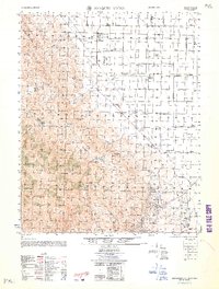
1962 Map of Joaquin Rocks
USGS Topo · Published 1962About this map
Joaquin Rocks towers over a landscape defined by the extraction of natural resources and large-scale ranching operations along the western edge of the San Joaquin Valley. This 1962 revision of 1950s data highlights the industrial footprint of the Coalinga Oil Field and the East Coalinga Extension Oil Field to the south, where a grid of pump jacks and storage tanks transformed the arid foothills. The area's agricultural character is recorded through numerous named property holdings, including the Giffen Cantua Ranch, Lillis Ranch, and Domengine Ranch, many of which were supported by infrastructure like the Mack Pumping Sta. The complex drainage systems of Cantua Creek and Martinez Creek cut through the Monocline Ridge, illustrating the challenging terrain that early Fresno County ranchers and oilmen navigated.
Find a feature on this map
41 named features on this map. Tap any name to fly to it.
Don’t see what you’re looking for? This feature index may not catch every label — zoom into the map to look around manually.
Map Details
Editions of this 1962 Joaquin Rocks Map
This is the sole edition of this map. No revisions or reprints were ever made.
Other maps of this area

1912 · Coalinga
USGS Topo · 1:125,000

1913 · Panoche
USGS Topo · 1:125,000

1915 · Priest Valley
USGS Topo · 1:125,000

1923 · Levis
USGS Topo · 1:31,680

1923 · Englebrecht Ranch
USGS Topo · 1:31,680

1923 · Monocline Ridge
USGS Topo · 1:31,680

1925 · San Joaquin
USGS Topo · 1:31,680

1928 · Delta Farms No 3
USGS Topo · 1:31,680

1931 · Towne Oil Station
USGS Topo · 1:31,680

1931 · Mouth of Cantua Creek
USGS Topo · 1:31,680