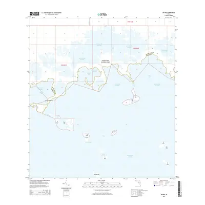
2015 Map of Joe Bay
USGS Topo · Published 2015About this map
Everglades National Park dominates this coastal landscape where the fresh water of the mainland meets the salt of the Atlantic Ocean. The map reveals an intricate network of mangrove-lined waterways, including Joe Bay, Little Madeira Bay, and Alligator Bay, which serve as vital transition zones between terrestrial and marine environments. The boundary between Miami-Dade and Monroe counties cuts through these tidal flats and basins, marking a transition from the mainland into the open waters of Florida Bay. Numerous small islands and hammocks dot the seascape, such as Fan Palm Hammock, Eagle Key, and Nest Keys, providing isolated terrestrial habitats amidst the surrounding shallows. Localized hydrological features like Trout Creek and Davis Cr illustrate the complex drainage patterns that define this subtropical wilderness. This 2015 update provides a modern reference for the shifting shorelines and protected islands of this coastal preserve.
Find a feature on this map
25 named features on this map. Tap any name to fly to it.
Don’t see what you’re looking for? This feature index may not catch every label — zoom into the map to look around manually.
Map Details
Editions of this 2015 Joe Bay Map
This is the sole edition of this map. No revisions or reprints were ever made.
Other maps of this area

1947 · Rock Harbor
USGS Topo · 1:24,000

1947 · Blackwater Sound
USGS Topo · 1:24,000

1949 · Blackwater Sound
USGS Topo · 1:24,000

1949 · Rock Harbor
USGS Topo · 1:24,000

1950 · Glades
USGS Topo · 1:24,000

1956 · Glades
USGS Topo · 1:24,000

1956 · Royal Palm Ranger Station SE
USGS Topo · 1:24,000

1956 · Miami
USGS Topo · 1:250,000

1958 · Miami
USGS Topo · 1:250,000

1967 · Royal Palm Ranger Station SE
USGS Topo · 1:24,000