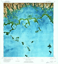
1972 Map of Joe Bay
USGS Topo · Published 1976About this map
Everglades National Park dominates this 1970s orthophotomap, showing a complex aquatic environment where the southern Florida mainland meets the Gulf. The landscape is defined by intricate tidal channels and mangrove-shrouded basins like Joe Bay and Little Madeira Bay. Unlike traditional topographic maps, this aerial-based survey uses color photography to reveal the actual density of vegetation and the subtle gradations of water depth across Florida Bay. Small islands and distinct landforms such as Eagle Key, Tern Keys, and the Palm Hammock provide rare solid ground amidst the expansive wetlands. Significant waterways including Devil Creek and Trout Cr drain the interior marshes into Davis Cove. The absence of roads or established trails on the sheet emphasizes the wilderness character of this region during the early 1970s, as researchers and conservationists documented the fragile boundary between fresh and salt water.
Find a feature on this map
22 named features on this map. Tap any name to fly to it.
Don’t see what you’re looking for? This feature index may not catch every label — zoom into the map to look around manually.
Map Details
Editions of this 1972 Joe Bay Map
This is the sole edition of this map. No revisions or reprints were ever made.
Other maps of this area

1947 · Rock Harbor
USGS Topo · 1:24,000

1947 · Blackwater Sound
USGS Topo · 1:24,000

1949 · Blackwater Sound
USGS Topo · 1:24,000

1949 · Rock Harbor
USGS Topo · 1:24,000

1950 · Glades
USGS Topo · 1:24,000

1956 · Glades
USGS Topo · 1:24,000

1956 · Royal Palm Ranger Station SE
USGS Topo · 1:24,000

1956 · Miami
USGS Topo · 1:250,000

1958 · Miami
USGS Topo · 1:250,000

1967 · Royal Palm Ranger Station SE
USGS Topo · 1:24,000