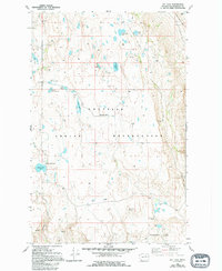
1980 Map of Joe Lake
USGS Topo · Published 1994About this map
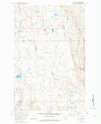
The Colville Indian Reservation in Okanogan County is characterized by a high plateau landscape dotted with numerous small lakes and basins. This 1980 survey reveals a rural landscape where social life and education were anchored by localized schoolhouses serving the ranching and agricultural families of the area. Named educational landmarks like Lang Lake School, Duley Lake School, and Cunningham School are positioned across the quadrangle, illustrating the distributed nature of the community before later consolidation. The terrain transitions from the open Timentwa Flats in the northwest to the more varied topography surrounding Joe Lake and the Achmin Basin. Water resources are a defining feature, ranging from the large Omak Lake in the northeast corner to smaller, distinctively shaped bodies like Figure Eight Lake and Freidlander Lake.
Find a feature on this map
25 named features on this map. Tap any name to fly to it.
Don’t see what you’re looking for? This feature index may not catch every label — zoom into the map to look around manually.
Map Details
Editions of this 1980 Joe Lake Map
2 editions found
Other maps of this area

1905 · Okanogan
USGS Topo · 1:125,000

1950 · Boot Mtn
USGS Topo · 1:62,500

1953 · Omak Lake
USGS Topo · 1:62,500

1954 · Okanogan
USGS Topo · 1:250,000

1957 · Okanogan
USGS Topo · 1:62,500

1957 · Bridgeport
USGS Topo · 1:62,500

1958 · Okanogan
USGS Topo · 1:250,000
1980 · Camp Seven
USGS Topo · 1:24,000

1980 · Okanogan
USGS Topo · 1:24,000
1980 · Boot Mountain
USGS Topo · 1:24,000